WatsApp Now
Uttarey Singalila Round trek is one of the longest treks in the region. The trail covers the complete Singalila range all the way from Uttarey (Sikkim) to the border with Nepal and finally reaching Goechala pass to witness world’s third highest mountain – Khangchendzonga, 8585m. Singalila trek is the only trekking route in this part of the Himalaya from where one can get spectacular view of Mt. Everest, Mt.Lhotshe, Mt.Makalu, Mt Khangchendzonga, Mt. Tenchingkhang and several others.
Duration: 15 Days 14 Nights
Short Itinerary
Day 1: pickup from (N J P) New Jalpaiguri railway station
Bagdogra Airport to Uttarey (1,950.mtrs) 165km appx.
Day 2: Uttarey (1,950.mtrs) to Chewabhanjyang (3,145.mtrs)
15.km appx.
Day 03: Side Excursion to Phoktey Dara (3588.mtrs).5km appx.
Day 04: Chewabhanjyang (3,145.mtrs to Dhoor
(4,760.mtrs).16km appx.
Day 05: Dhoor (4,760.mtrs) to Sikkim Meghu (3,916.mtrs).13km
appx.
Day 06: Sikkim Meghu (3,916.mtrs) to Lampokhari
(4,323.mtrs).11km appx.
Day 07: Lampokhari (4,323.mtrs) to Gomathang (3,796.mtrs).
10km appx.
Day 08: Gomathang (3,796mtrs) to Pangding (4,317mtrs) 15km
appx.
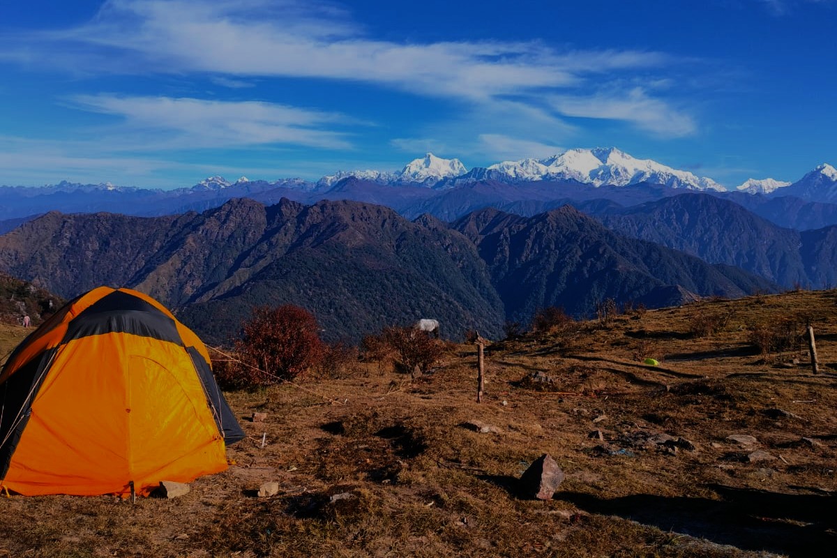
Day 09: Pangding (4,317.mtrs) to Dzongri (3950.metrs).10km
appx.
Day 10: Dzongri (3970m) to Thangsing (3800m). 10km appx.
Day 11: Thangsing (3800m) to Lamuney (3950m). 3.5km appx.
Day 12: Lamuney (3950m) to View Point 1 (4600m) and back to
Kokchurang (3600m). 15km appx.
Day 13: Kokchurung to Tshoka
Day 14: Tsokha (2950m) to Yuksom (1750m). 16km appx.
Day 15: Leave to Yuksom (1750m) to Bagdogra Airport/N J P.
Detailed Itinerary
Day 1: pickup from (N J P) New Jalpaiguri railway station
Bagdogra Airport to Uttarey (1,950.mtrs) 165km appx.
It is a 6 to 7 hour ride through the hills. Upon arrival in
Uttarey prepare for the trek 15km next day. If time permits, one could also see
around Uttarey Tenzing Hilleary Park, monastery, and local attractions.
Additionally, Uttarey is famous trek point of Indio-Nepal border.
Day 2 : Uttarey (1,950.mtrs) to Chewabhanjyang (3,145.mtrs)
15.km appx.
Our ascent takes us to the upper reaches of the Singalila
Ridge, which forms the border between Sikkim and Nepal. We pass through a rich
and dense forest, swathes of Rhododendrons, open ridges, sacred lakes and
remote trails. Our first day takes us to Chewabhanjyang. An easy trail rises
gently through the rainforest until a final steep ascent for the last couple of
hours brings us right up to the Nepalese border and our first camp. We spend
the following day here for necessary acclimatization before further ascending.
Day 3: Side Excursion to Phoktey Dara (3588.mtrs).5km appx.
A walk to Phoktey Dara in the wee hours of the morning
provides one of the most breath-taking panoramic view of the Sikkim and Nepal
ranges.
Phoktey Dara (3,618m) is at a junction between Sikkim, Nepal
and West Bengal and the borders meet here. You will have a full view of
towering peaks including Mt. Everest, Makalu, Nuptse, Lhotse, Three sisters,
Kumbakarna, Kanchenjunga and several other peaks in the region. This is one of
the best grand-stand views one will get of the majestic Himalayas from anywhere
in the mountains.
Day 4: Chewabhanjyang (3,145.mtrs to Dhoor (4,760.mtrs).16km
appx.
A gentle uphill traverse through forests and then over a
more exposed hill side brings us to prayer flags adorning our first trail near
Major Dara and views of distant mountains – a taste of what is to come. As we
gradually gain height we will appreciate the previous day’s acclimatization.
The occasional yak herders hut is the only sign of habitation as we look down
far below to the rice fields and cardamom plantations. Our camp is in a remote
and sheltered hollow below the ridge.
Day 5: Dhoor (4,760.mtrs) to Sikkim Meghu (3,916.mtrs).13km
appx.
Throughout the day we alternately descend and climb,
maintaining a steady height, spiralling from one side of the ridge to the other
until a rough steep ascent takes us across a pass. Beyond, the trail winds its
way steadily through Rhododendrons and past several Hindu shrines where a
second easier pass drops down to our camp close to a Shepherd’s summer
settlement. Watch the Blue Sheep on the high craggy mountainside.
Day 6: Sikkim Meghu (3,916.mtrs) to Lampokhari
(4,323.mtrs).11km appx.
We walk easily on a good trail through woods until we begin
a steady rise up a broad valley where we catch our first closer view of the
entire Kabru Range and a dominant Mt. Pandim (6,691m). A further two hours of
ascent will get us to our camp with Everest and a host of other Khumbu Giants
dominating the distant skyline. An afternoon of rest and acclimatization for
the following day’s foot slogging.
Day 7 : Lampokhari (4,323.mtrs) to Gomathang (3,796.mtrs).
10km appx.
Sparse vegetation can be seen as we mount up higher. A
little snow underfoot can be expected as we climb to our first pass, the
Danphey Bhir La at 4,530m, the Pass of the Pheasant. From here it is possible
to see the whole of Sikkim with the view stretching out well into Tibet and
Bhutan. A further hours contouring and a small ascent reveals the Kag Bhir La,
(the Pass of the Crow) where we may be lucky enough to get the closest view of
the panorama of the Himalayan peaks including Majestic Khangchendzonga. Reluctantly,
we then must head downhill making a steep descent to our river side camp
Gomathang. The camp is located in a beautiful meadow and is a great place to
rest for the night.
Day 8: Gomathang (3,796mtrs) to Pangding (4,317mtrs) 15km
appx.
This day we have to climb through forests of sweet smelling
silver fir and rhododendrons. Soon we are in high mountains terrain again. The
route goes up and down over the hills culminating with a stiff ascent as we
near Pangding. Pangding offers the view of almost all the important peaks and
ranges of this trek.
Day 9: Pangding (4,317.mtrs) to Dzongri (3950.metrs).10km
appx.
First trekkers have to descend down to Tigap Chu (3,700m)
and then ascend up to Dzongri crossing Rathong Chu River. As Tigap chu is lower
in altitude big pine trees and rhododendron bushes become visible and large
rocks dominates the area. It offers a nice area to rest. After refreshment
climb begans to Dzongri, a campsite at the junction of several trekking trails
in the region.
Day 10 : Dzongri (3970m) to Thangsing (3800m). 10km appx.
This day you ascend a little from the Dzongri campsite and
then walk through meadows with gentle up and down slopes till you arrive at the
steep descent to the Kokchurang campsite by the Prek chu. The descent is
challenging for almost everyone and can take around an hour. Kokchurang
campsite is nestled in a dense forest by the river side and is a perfect spot
to rest for a while. We do not set up camp here on our way up. After some rest,
we proceed to Thangsing, our camp for the night, through some more beautiful
forest. On a clear day, the Thangsing campsite gives you a welcome gift of
outstanding views of Mt. Pandim right upon arrival. Soak in the beauty of the
sights before you and surrender to nature’s splendour. Thangsing is a wide open
field and you will often find trekkers or local staff playing cricket, football
or volleyball here. Join in for some fun and to test your lungs!
Day 11: Thangsing (3800m) to Lamuney (3950m). 3.5km appx.
It is the simplest day of the trek. A very gradual gain from
Thangsing will take you to Lamuney in 1.5 hours. Start late by 10 am and you
will still reach Lamuney by 11:30am. Relax at camp. The following morning you
will be up early and leave for View Point 1 around 2:30am.
Day 12: Lamuney (3950m) to View Point 1 (4600m) and back to
Kokchurang (3600m). 15km appx.
The day starts early at 2:30am. It will be biting cold at
this hour and one must be prepared for it. Typically the temperature will be
below zero at start. Start slowly and cross the Samiti Lake in the dark on your
way up to the view point. The start is timed to take you the view point around
first light and before sunrise for, as beautiful as first light looks on the
peaks, the sunrise is pure magic. Peaks light up in the descending order of
altitude with Kanchenjunga first to be lit followed by kabru north and then the
lower peaks in order. The route used to be open right up to the Goecha la
earlier. However, the NAtional park authorities have closed the route beyond
view point 1 now as the zone beyond it has been identified as having
significant concentration of blue sheep and the snow leopard. This area is a
breeding zone for these species as well and has been demarcated as a
conservation zone to reduce human interference. Carry a pair of binoculars with
you to give yourself a chance of spotting a rare leopard or a flock of blue
sheep. Leopard sightings are very rare as they are extremely shy and if you see
one, count yourself very very lucky! Descend to Samiti Lake on your way back to
the camp. Around 8am, when you are likely to be back at Samiti, the water is
very still usually and a full reflection of the peaks around it is visible in
the water. Several birds will be out by now and the area around the lake is a
great place for photography aficionados. Come back to camp at Lamuney, have an
early lunch and move down to Kokchurang campsite next to the river for the
night. It is warmer here and of course very beautiful.
Day 13: Kokchurung to Tshoka
The walk from Kokchurang to Phedang is through a very dense
forest and no pack animals can do this trail due to the narrow nature and dense
vegetation on the trail. For several hours you will walk through forests that
might remind some of the forests in the Indian Western Ghats during monsoons.
This part of the trail takes about 4-5 hours typically. Have the packed lunch
provided to you, here. From Phedang turn left and down towards Tsokha. It is a
continuous descent up to Tsokha and takes up 2 hours.
DAY 14 : Tsokha (2950m) to Yuksom (1750m). 16km appx.
Last day of the trek takes you back over the same route you
took to come up. Descend all the way to the suspension bridge over Prek Chu
below Bakhim. It can take anywhere between 1.5 to 2.5 hours. From the bridge
there is a climb for about 20mins after which the trail takes you over gentle
ups and downs while constantly losing altitude towards yuksom. Expect yourself
to reach Yuksom in between 5-7 hours. You will have packed lunch on this day as
well and Sachen is a good point to take a break. As you near Yuksom mobile
networks will become active again. Reach the road head and you are standing at
the end point of the trek. A cozy bed and hot water will be waiting for you at
your hotel/homestay.
Day 15: Yuksom to NJP/Bagdogra or other destinations.
ON REQUEST
ON REQUEST